A new online tool seeks to help Indiana communities understand how climate change will affect Hoosiers locally and what they can do to minimize new dangers.
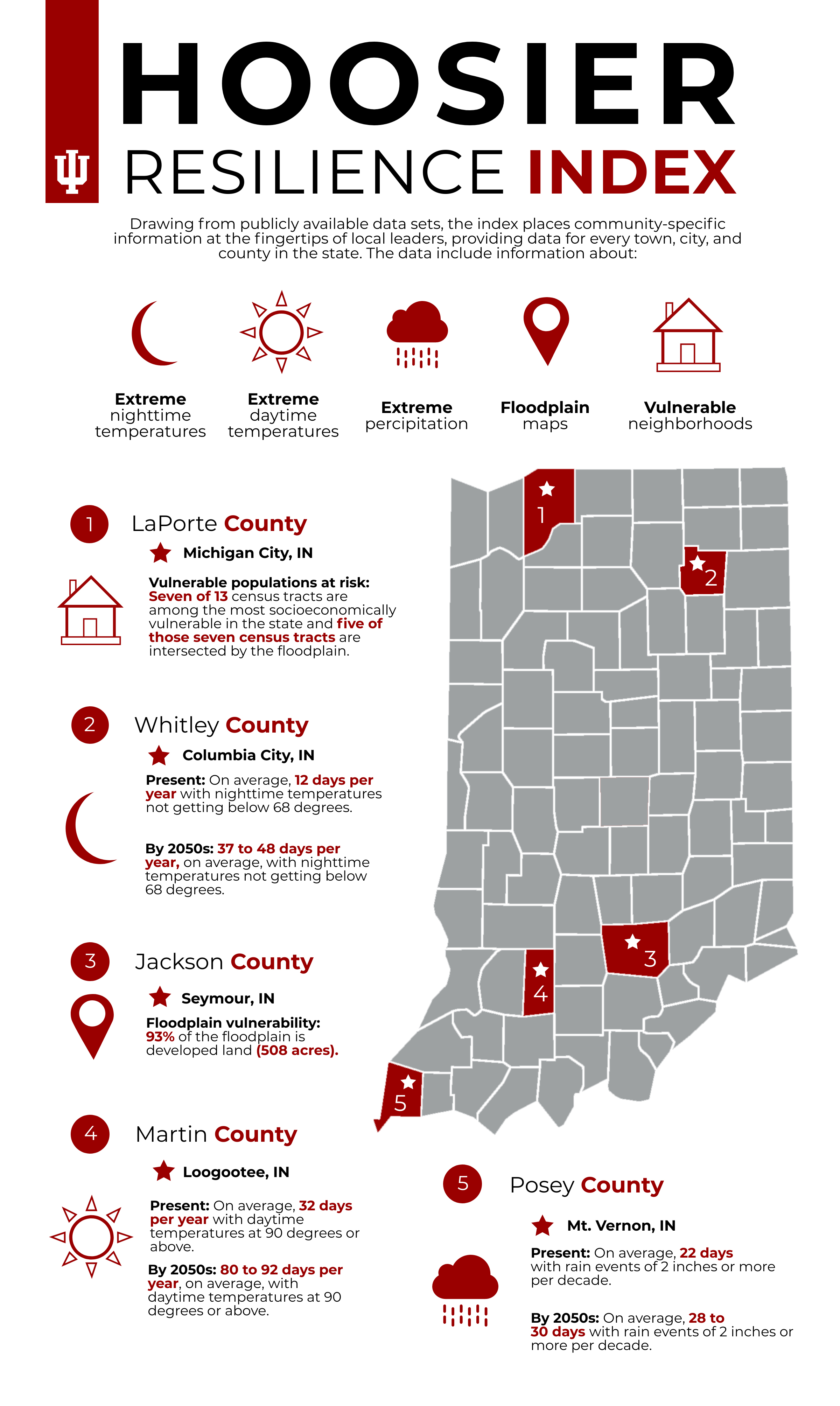
Indiana University’s Environmental Resilience Institute launched the Hoosier Resilience Index, an online database that makes available community-specific information – like precipitation, flood plain and land use maps – for every community in the state of Indiana.
By using the publicly available data, local governments can find out how ready they are to deal with the temperature and precipitation changes happening now and those expected to happen in the near future.
“The Hoosier Resilience Index will allow them to get a sense of the vulnerabilities that they face from climate change as they are happening in our state and that will be increasing in severity,” said Janet McCabe, director of the Environmental Resilience Institute at Indiana University. “And, importantly, once they know those vulnerabilities, they will be able to work through a series of questions to help them assess how ready they are to be resilient in the face of those changes.”

Climate change has forced Hoosiers to modify the way they live and work, a fact that is becoming more apparent every year.
Average yearly precipitation in Indiana has been on the rise since the 1950s.
“Scientists have looked very carefully at all the different predictions for what’s going to happen to precipitation in the state due to climate changes. We are going to have more precipitation. On average about 16% more in the winter and spring, and we’re going to have less in the summer and fall,” said McCabe.
The National Oceanic and Atmospheric Administration found that average precipitation in the contiguous United States in the past 12 months was 6.28 inches above average. This year also had the wettest January through October in the contiguous U.S. on record.
The increased precipitation has resulted in more historic flooding events in the state throughout the years. This year, increased rainfall delayed the planting of Indiana’s corn and soybean crops by months, disrupting the state’s agricultural industry.

McCabe said the Hoosier Resilience Index will help local leaders make plans for dealing with the increased precipitation and other weather changes induced by a changing climate.
“What the Index does is take that information down to the local level, and nobody has done that before,” said McCabe. “Communities across Indiana are just beginning, really, to think about needing to be resilient. And, frankly, the wake-up call has been the flooding. It can affect health, it can cost a lot of money, it can be extremely disruptive and create public safety problems. So, we wanted to make sure that our tool would be providing information to communities that they don’t already have.”
The Index compiles information from state and federal sources like the Indiana Climate Change Impacts Assessment, the U.S. Census Bureau and the U.S. Environmental Protection Agency to help communities develop plans based on threats specific to their area.
The Environmental Resilience Institute consulted state and local officials for the index and worked with four communities to test how the information could best be used to create resiliency plans.
McCabe said officials from smaller communities often struggled to find data relevant to their communities. The Index was designed to give everyone the information they needed to be able to prepare for likely future situations.
“As our environment changes, and our relationship to it evolves, we know that we have to be ready,” said Noble County plan director Kenneth Hughes. “The Index is going to help us examine our plans and determine next steps based on our risk. Local governments across the state have been working on strengthening infrastructure and building more resiliently, and this tool helps provide support for these efforts.”
Although some communities may need to undertake large projects to ensure they will be able to be resilient in the face of climate change, many communities may only need to adjust common daily operations in order to be prepared.
“What we hope and what we expect is that when communities use this tool, they can understand where they’re at presently and what actions they can take next to be better prepared,” said ERI implementation manager Andrea Webster. “One example of that is street sweeping. Some surface flooding happens when our storm drains are plugged with leaves, especially this time of year. And so, if communities can increase and regulate their street sweeping services then they’re less likely to clog those drains and less likely to experience flooding as a result.”
The Hoosier Resilience Index is free to use. The ERI will hold training webinars for the Index beginning Dec. 2.